Overview
The REDCOAST.LTD RC-RWIS-300 is a grid-powered Road Weather Information System (RWIS) engineered for highway agencies, toll concessionaires, airport authorities and infrastructure operators that need real-time, actionable knowledge of pavement and atmospheric conditions. Built around a self-developed multi-channel signal conditioning PCB, an edge fusion gateway, and an NTCIP 1204-compliant Environmental Sensor Station controller, the system measures everything a winter, fog or sandstorm operations center needs: surface state (dry / moist / wet / ice / snow / slush / chemical-wet), water film depth, friction (Grip scale), freeze point of residual chemicals, sub-surface temperatures, air temperature / humidity / dew point, wind speed and direction, barometric pressure, precipitation type and intensity, and atmospheric visibility. The output is not raw data dumped at a server — it is a classified, validated, geo-tagged road state per minute, ready to drive variable speed limits, dispatch winter maintenance crews, trigger fog or ice warnings on Variable Message Signs, and feed Connected Vehicle infrastructure with credible roadway condition data.
Key Features
- Full NTCIP 1204 v04 ESS compliance — integrates natively with existing Traffic Management Centers and ATMS platforms, no custom protocol bridges required.
- Self-developed multi-channel signal conditioning PCB — 8× isolated PT100/PT1000 RTD, 8× 4–20 mA, 4× frequency, 4× SDI-12, 4× RS-485 MODBUS, 4× digital inputs — handles every mainstream meteorological and pavement sensor brand on the market.
- Choice of invasive (in-pavement IRS-31 class) or non-invasive (pole-mounted radar / IR) pavement sensing, or both for ground-truth fusion on high-stakes corridors.
- Edge sensor fusion and state classification — per-minute road state, Grip friction (0.05–0.82), residual chemical concentration and freeze-point estimation, all in NTCIP-native enumerations.
- Visibility 10 m – 75 km via forward-scatter sensor with discrimination of fog, mist, rain, snow and blowing dust.
- Sonic anemometry (no moving parts) handles desert dust, freezing fog and salt-laden coastal air without seizing or icing up.
- Cross-domain integration — pushes set-points and trigger events to NTCIP 1203 Variable Message Signs, NTCIP 1202 traffic signal controllers, SCADA / OPC UA control rooms, and any MQTT cloud.
- Active cabinet thermal management — fans, heaters and condensation control keep electronics within spec from -40 to +70 °C.
- Class I + II surge protection on all sensor lines and AC mains, with single-point grounding designed per IEC 62305.
- LiFePO4 UPS keeps the station online and reporting through 4–8 hours of grid outages — critical because storm events are precisely when grids fail and operators need data the most.
- Cloud platform plus iOS / Android app delivered with the station — agency users see road state on a map, configure alarms, audit calibration history, and pull data for post-incident analysis.
Technical Architecture
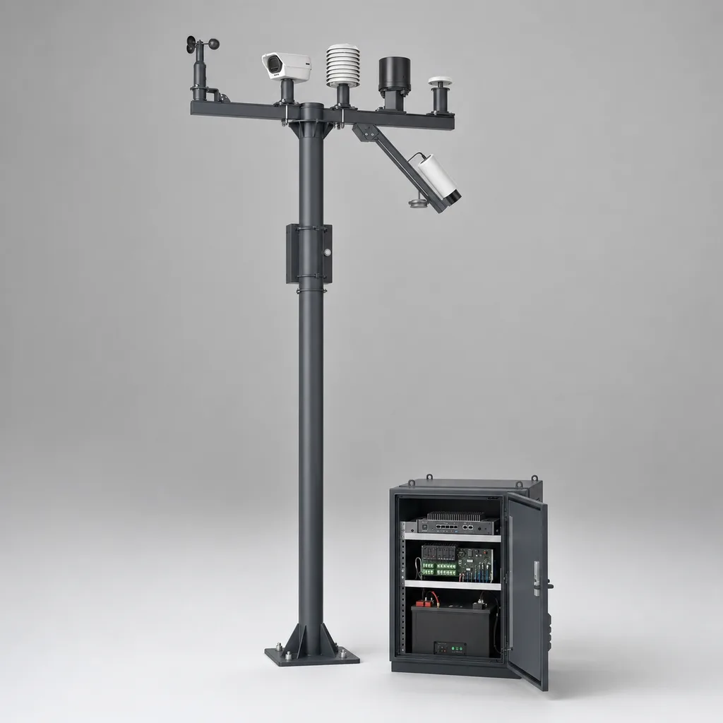
A typical RC-RWIS-300 station consists of a roadside cabinet, a sensor mast, and (optionally) in-pavement sensors installed in the travel lane. The cabinet houses the edge gateway, the REDCOAST.LTD signal conditioning and cabinet management PCBs, a LiFePO4 UPS, the AC distribution and surge protection, and the cellular or fiber communication module. The sensor mast — typically 6 m, hot-dip galvanized then powder-coated to a smooth matte RAL 7016 anthracite finish — carries the atmospheric sensor cluster: combined air temperature / humidity probe in a radiation shield, ultrasonic 2-axis anemometer, barometric pressure transmitter, optical disdrometer for precipitation type and intensity, forward-scatter visibility sensor, and, if specified, a non-invasive pavement sensor pointed at the lane. In-pavement sensors, when used, are flush-mounted in cores cut into the travel lane and wired back to the cabinet through buried conduit.
Inside the edge gateway, a Linux-based ARM Cortex-A55 platform samples each channel at 1 Hz, applies vendor-specific linearization and compensation, validates ranges, and runs a fusion algorithm that converts raw measurements into an NTCIP 1204 ESS data structure. Pavement state classification follows the NTCIP essSurfaceStatus enumeration, and friction is reported on the international Grip scale. Local logic triggers thresholds in real time — for example, raising an ice imminent alarm when pavement temperature crosses dew point with surface state moist, or escalating a visibility critical event when forward-scatter readings fall below 200 m for more than 90 seconds. Alarms are simultaneously pushed to the cloud platform, the mobile app, the local NTCIP datagram queue and any subscribed downstream system (ATMS, SCADA, MQTT broker).
Connectivity & Power
Stations are AC mains powered (100–240 V, 50/60 Hz) and tapped into existing highway electrical infrastructure, typically the lighting feeder. Power draw is 35–80 W typical, with peaks to 150 W when sensor heaters engage in freezing conditions. A LiFePO4 12 V / 40 Ah UPS sustains 4–8 hours of full operation during grid outages — long enough to ride through the storm events when condition data is most valuable. Primary backhaul is 4G LTE Cat-4 (5G NSA / SA optional), with Gigabit Ethernet as a wired alternative or redundant link for fiber-served corridors. Local service access is via Wi-Fi 5 for on-site commissioning and calibration. Protocols include NTCIP 1204 over UDP/IP, MQTT for cloud, OPC UA for SCADA integration, and Modbus TCP for legacy ITS hardware. Because RC-RWIS-300 targets grid-served roadways, it does not ship with a solar panel by default — solar makes no sense as a primary supply alongside a highway lighting circuit and would add cost without benefit. For truly remote tail-end stations REDCOAST.LTD can specify a Grid + Solar backup variant on request.
Protection & Reliability
The roadside cabinet carries an IP55 rating with powder-coated steel (aluminum optional) construction, active fan / heater thermal management, intrusion alarm, and a single-point Class A earthing per IEC 62305. Sensor housings and mast components are IP66 or higher and qualified to ISO 9223 Category C5 for coastal salt-spray corrosion. Operating range is -40 to +70 °C, covering everything from Nordic winters to Gulf and desert summers. The MTBF target on the electronics package is greater than 50,000 hours, and every signal conditioning channel is independently isolated, so a sensor short cannot propagate to the gateway. EMC and surge testing follows IEC 61000-4 and IEC 61643 (Class I + II combined SPDs on AC mains, dedicated SPDs on every signal line and on the cellular antenna feed). Pole foundation and cabinet anchoring are engineered for project-specific wind loads (typical 36–48 m/s 10-minute mean, EN 1991-1-4).
Application Scenarios
- Mountain pass winter operations — Stations spaced every 5–15 km along high-elevation corridors stream surface state and friction back to a maintenance control room, so plows and brine trucks are dispatched only where and when they are needed, cutting chemical use while improving response time on actual ice events.
- Bridge-deck black-ice early warning — Bridges freeze before adjacent roadway, especially on overpasses and long-span structures. A dedicated RC-RWIS-300 on each at-risk bridge approach feeds a nearby Variable Message Sign that activates BRIDGE ICE warnings the moment pavement temperature drops below dew point with moisture present.
- Coastal and valley fog corridors — Forward-scatter visibility plus crosswind data trigger automatic variable-speed-limit advisories before drivers run into a fog wall — useful on highway segments along coastal lowlands, river valleys and lake basins.
- Desert and sandstorm-prone highways — Visibility plus optional PM10 / PM2.5 channel and crosswind detection support automatic lane-closure recommendations when a dust event reduces visibility below safe operating thresholds.
- Airport landside and runway environmental monitoring — Pavement state on aircraft pavements and access roads, plus crosswind on approach corridors, supports airport operations decision-making, integrated with ATC and ground-handling systems.
- Toll road network maintenance dispatching — A backbone of RC-RWIS-300 stations across a concession provides condition-based dispatch for winter maintenance, drainage inspection during heavy rain, and post-incident climate forensics that protects against liability claims.
Case-style Examples
- Mountain corridor winter optimization — A highway operator deployed twelve RC-RWIS-300 stations across an 80 km mountain corridor known for sudden ice events. Each station combined in-pavement sensors in the slow lane with a pole-mounted non-invasive sensor for cross-check. The fusion gateway pushed state to the operator's existing ATMS via NTCIP 1204 and triggered REDCOAST.LTD Variable Message Signs already deployed on the corridor. The configuration replaced a fixed-schedule plowing program with condition-based dispatch, with reported savings on de-icing chemical and overtime hours while improving customer-perceived service quality during storms.
- Coastal fog bridge approach — A long bridge crossing a coastal estuary had a documented fog-related crash history. Three RC-RWIS-300 stations were sited on each approach, each pairing a forward-scatter visibility sensor with a sonic anemometer and pavement state sensor. The system now raises advisory speed limits on the bridge VMS automatically when visibility drops below 500 m, with manual override from the operations center. Crash incidents during fog season decreased markedly after commissioning.
- Desert highway dust-storm safety — On a long inland highway prone to seasonal dust storms, an operator deployed eight RC-RWIS-300 stations with the desert option (PM10 channel, salt-fog-rated housing, enhanced surge protection, IP66 sand-tight sensor cluster). The stations feed an operations dashboard and trigger predefined VMS messages when crosswinds exceed thresholds or visibility falls below 500 m, enabling proactive lane closures rather than reactive accident response.
Customization & Selection Guide
- Sensor package — Basic (air temp / humidity, wind, rain, pavement state); Standard (adds visibility, friction, water film); Premium (adds dual pavement sensors, lightning detection, spectral visibility for fog vs dust discrimination, PM10 / PM2.5).
- Pavement sensing approach — Invasive IRS-31-class is most accurate but requires lane closure to install; non-invasive radar / IR avoids pavement cuts and is faster to deploy; hybrid is recommended for benchmarking and high-stakes corridors.
- Cabinet size — Compact 600 × 800 × 300 mm for tight roadside footprints; full 1200 × 800 × 400 mm where the station also hosts edge-AI inference or third-party ITS equipment.
- Connectivity — Cellular-only for greenfield deployments; redundant fiber + cellular for trunk corridors; mesh microwave when neither is available.
- Integration depth — Standalone (NTCIP datagrams plus cloud only); ATMS-integrated (push to existing TMC); full SCADA / OPC UA for highway tunnel or industrial sites.
- Station spacing — Typically 5–10 km in winter mountain corridors, 10–25 km on flat highways, dense (every bridge) for ice-prone structures, every fog-bank entry on coastal routes.
Deployment & After-sales
REDCOAST.LTD delivers RC-RWIS-300 as a turn-key package: site survey, foundation and conduit design, civil-works coordination support, factory pre-integration and burn-in, sensor calibration on site, NTCIP integration testing with the customer's ATMS, and operator training on the cloud platform and mobile app. Typical per-station deployment is five to ten working days on civil-ready sites. Remote diagnostics, predictive maintenance based on sensor drift trends, OTA firmware updates and a 12-to-24 month standard warranty (extendable) are included. Spare parts and calibration kits are stocked for fast field repair, and REDCOAST.LTD engineers are available for project-specific firmware features (custom alarm logic, bespoke ATMS integration, regional language support in the app and platform). Lead time for standard configurations is 6–10 weeks from order; larger network rollouts ship in scheduled batches aligned to civil-works progress.
Standards & Compliance
- NTCIP 1204 v04 Environmental Sensor Station data dictionary and object definitions
- WMO No. 8 Guide to Meteorological Instruments and Methods of Observation
- EN 15518 Road Weather Information Systems (European specification framework)
- IEC 60529 Ingress protection (IP55 cabinet, IP66 sensors)
- IEC 61000-4 EMC immunity for ITS roadside equipment
- IEC 61643 Class I + II surge protection on AC mains and signal lines
- IEC 62305 Lightning protection and earthing design
- ISO 9223 Atmospheric corrosion classification (Category C5 supported)
- EN 1991-1-4 Wind loading on supporting structures
- CE / RoHS / FCC as standard; project-specific certifications available on request
Why REDCOAST.LTD
REDCOAST.LTD delivers RC-RWIS-300 as a single-team, end-to-end solution — not a bag of OEM sensors with a third-party logger. The signal conditioning PCB, the cabinet management PCB, the edge gateway firmware, the NTCIP stack, the cloud platform and the operator mobile app are all developed in-house. That means we can adapt the PCB to a sensor mix that other vendors would not support, port the firmware to a regional ATMS protocol variant, white-label the platform under the operator's brand, and turn a project around without waiting on third-party roadmaps. Self-developing the hardware also drives lifecycle cost down — fewer parts, fewer suppliers, clean spares strategy. For agencies and integrators planning RWIS networks, this is the difference between a procurement that locks you into a vendor stack and one that gives you a system you actually control.
Contact REDCOAST.LTD for a free corridor assessment, a sensor-package recommendation, and a tailored RWIS proposal for your highway, bridge, airport or industrial site — we respond within one business day with engineering input, not a brochure.
Specifications
Atmospheric Sensors
- Air Temperature
- -50 to +60 °C, accuracy ±0.2°C
- Relative Humidity
- 0-100 %, accuracy ±2%
- Wind Speed (Sonic)
- 0-75 m/s, no moving parts
- Wind Direction
- 0-360 °, accuracy ±2°
- Barometric Pressure
- 500-1100 hPa
- Precipitation (Optical Disdrometer)
- 0.001-200 mm/h, type-discriminating
- Visibility (Forward-Scatter)
- 10 - 75,000 m
- Lightning Detection (optional)
- 0-40 km range
Pavement Sensors
- Surface Temperature
- -40 to +80 °C, accuracy ±0.5°C
- Sub-Surface Temperature
- 5 / 10 / 20 / 30 cm depth probes
- Surface State (NTCIP enum)
- dry / moist / wet / ice / snow / slush / chemical-wet
- Water Film Depth
- 0-6 mm, resolution 0.1 mm
- Friction (Grip scale)
- 0.05-0.82
- Freeze Point (residual chemical)
- -25 to 0 °C
- Sensor Type
- Invasive IRS-31 class / Non-invasive radar+IR / Hybrid
Edge Gateway & Processing
- CPU
- ARM Cortex-A55 quad-core
- RAM / Storage
- 4 / 32 GB DDR4 / GB eMMC + 64 GB industrial SD
- Analog I/O
- 8× RTD + 8× 4–20 mA + 4× frequency + 4× digital isolated
- Serial / Field Bus
- 4× SDI-12 + 4× RS-485 MODBUS isolated
- Sampling Rate
- 1 Hz per channel, configurable to 10 Hz
- Edge Functions
- State classification, friction estimate, nowcasting, alarm logic, NTCIP 1204 stack
- Operating System
- Hardened Linux, secure boot, signed OTA updates
- Cybersecurity
- TLS 1.3, X.509 device certificates, role-based access, audit logging
Connectivity
- Primary Backhaul
- 4G LTE Cat-4 (5G NSA / SA optional)
- Wired Backhaul
- Gigabit Ethernet, SFP fiber slot optional
- Service Access
- Wi-Fi 5 (commissioning port)
- Standard Protocols
- NTCIP 1204 over UDP/IP, MQTT, OPC UA, Modbus TCP, REST
- Time Sync
- NTP / PTP IEEE 1588 with GNSS holdover
- Concurrent Downstream
- up to 8 ATMS / SCADA / cloud subscribers
Power (Grid-Powered)
- Input Voltage
- AC 100-240 V, 50/60 Hz
- Power Consumption (typical)
- 35-80 W
- Power Consumption (peak, heaters on)
- 150 W
- UPS Battery
- LiFePO4 12 V / 40 Ah
- UPS Autonomy
- 4-8 h full operation
- Surge Protection
- Class I + II per IEC 61643 on AC mains and every signal line
- Sensor Heaters
- 24 V DC thermostat-controlled (visibility, anemometer, precipitation)
Cabinet & Mechanical
- Cabinet IP Rating
- IP55
- Cabinet Construction
- Powder-coated steel (aluminum optional), RAL 7016 anthracite
- Cabinet Dimensions
- 600×800×300 (compact) or 1200×800×400 (full) mm
- Thermal Management
- Dual DC fans + 200 W heater, condensation control
- Mast Height
- 4 / 6 / 9 m, hot-dip galvanized + powder-coated
- Sensor Crossarm
- 2 - 3 arms, 1 m each
- Earthing
- Class A single-point per IEC 62305
- Intrusion Alarm
- Door sensor + tamper switch, alarm to ATMS
Environmental & Compliance
- Operating Temperature
- -40 to +70 °C
- Storage Temperature
- -50 to +85 °C
- Humidity
- 0-100 % RH condensing
- Corrosion Category
- ISO 9223 Category C5 (coastal / industrial)
- Wind Load Design
- 36-48 m/s 10-minute mean per EN 1991-1-4
- Standards
- NTCIP 1204 v04, WMO No.8, EN 15518, IEC 60529 / 61000-4 / 61643 / 62305
- Certifications
- CE, RoHS, FCC (project certs on request)
- MTBF Target
- >50,000 h
Capabilities — configurable per project
Specifications are tailored to each project — the options below show what we can support.
Power Source
- Grid AC only
- Grid AC + LiFePO4 UPS (default)
- Grid AC + LiFePO4 + Solar backup (remote tail-end)
Sensor Package
- Basic Met (4 sensors)
- Standard RWIS (8 sensors)
- Premium RWIS (12+ sensors, dual pavement, lightning, spectral visibility, PM10)
Pavement Sensing
- Invasive IRS-31 class (in-pavement)
- Non-invasive radar + IR (pole-mounted)
- Hybrid (both, fused)
Connectivity
- 4G/5G cellular only
- Cellular + Gigabit Ethernet
- Fiber + Cellular redundant
- Mesh microwave
Integration Depth
- Standalone (NTCIP + cloud)
- ATMS-integrated
- SCADA / OPC UA
- MQTT-only cloud
Related solution guidance

Environmental Monitoring
Deploy environmental monitoring stations with sensors, solar power, gateways, dashboards, alarms and data integration for city and industrial sites.
Solar IoT Guide
A design guide for solar-powered outdoor IoT: load calculation, battery autonomy, low-power firmware, telemetry and maintenance planning.

Traffic Safety
Plan connected traffic safety systems with warning beacons, LED signs, road guidance devices, sensing, control cabinets and monitoring software.
Frequently Asked Questions
What is a Road Weather Information System (RWIS) and how is it different from a generic weather station?
An RWIS is a roadside system that monitors both atmospheric weather and pavement conditions (surface state, water film, friction, freeze point, sub-surface temperatures) specifically to support highway and airport safety and maintenance decisions. A generic weather station only reports atmospheric variables. The RC-RWIS-300 combines both and outputs classified road state per NTCIP 1204 enumerations, ready to drive variable speed limits, winter maintenance dispatch and VMS warnings.
Is the RC-RWIS-300 NTCIP 1204 compliant?
Yes. The edge gateway implements NTCIP 1204 v04 Environmental Sensor Station object definitions and reports surface state, friction (Grip), water film, freeze point, atmospheric temperature/humidity, wind, pressure, precipitation and visibility natively. It integrates with any NTCIP-aware ATMS without custom protocol bridges. It also speaks MQTT, OPC UA, Modbus TCP and REST for non-NTCIP integrations.
Should I choose invasive (in-pavement) or non-invasive pavement sensors?
Invasive IRS-31-class sensors give the most accurate readings of surface state, water film and freeze point because they sit in the pavement itself, but they require a lane closure to install and core the pavement. Non-invasive radar+IR sensors mount on a pole and avoid pavement cuts, making them faster to deploy and friendlier for active highways, with very good accuracy for state and water film. For high-stakes corridors like bridges or mountain passes, REDCOAST.LTD recommends a hybrid configuration that fuses both.
What is the typical station spacing along a highway?
Typical spacing is 5–15 km on winter mountain corridors where conditions change rapidly, 10–25 km on flat highways, and a dedicated station on every ice-prone bridge or fog-bank entry. Spacing should be set after a corridor assessment that looks at microclimate, elevation, exposure and historical incident patterns — REDCOAST.LTD provides this assessment free as part of a proposal.
Can the RWIS automatically trigger Variable Message Signs and variable speed limits?
Yes. The edge gateway can directly drive NTCIP 1203 Variable Message Signs and feed variable-speed-limit logic in the ATMS. Built-in rules cover ice imminent, snow on pavement, low visibility, high crosswind and heavy precipitation events, and custom rules can be added per project — for example, a multi-condition rule for bridge-deck black ice that combines pavement temperature, dew point and surface state.
Why is the station grid-powered and not solar?
RWIS stations are deployed along highways that already have electrical infrastructure (typically the lighting feeder), so grid power is reliable, cheaper, and supports the peak loads of sensor heaters in freezing conditions. Adding solar as the primary supply would inflate cost without operational benefit. For truly remote tail-end stations REDCOAST.LTD offers a Grid + Solar backup variant, and for fully off-grid weather monitoring we offer the separate solar Automatic Weather Station product.
How long can the station keep operating during a grid outage?
The on-board LiFePO4 12 V / 40 Ah UPS sustains 4–8 hours of full operation, depending on sensor heater load. Larger UPS capacities are available on request for sites with poor grid reliability. Critically, NTCIP reporting, alarm logic and cellular backhaul stay live throughout the outage — which matters because storms are when the grid fails and the data is most valuable.
What standards does the RC-RWIS-300 meet?
NTCIP 1204 v04 (ESS data dictionary), WMO No.8 (meteorological measurement), EN 15518 (European RWIS framework), IEC 60529 (IP55 cabinet, IP66 sensors), IEC 61000-4 (EMC), IEC 61643 (Class I+II surge), IEC 62305 (lightning), ISO 9223 (C5 corrosion), EN 1991-1-4 (wind load), plus CE / RoHS / FCC as standard. Project-specific certifications are arranged on request.