Overview
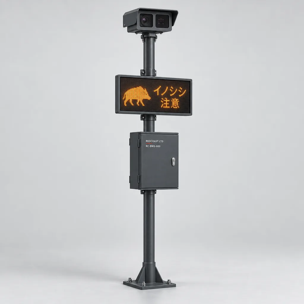
The RC-BWS-600 is a grid-powered wild boar detection and human–wildlife conflict warning system for public parks, residential estates, campuses, and managed recreational grounds beside woodland. REDCOAST.LTD combines thermal and visible-light sensing, local AI processing, pedestrian information signs, and an integrated web platform and mobile app to help operators identify animal activity and redirect people before close encounters occur. Wildlife authorities identify parks and residential areas as locations where wild boar encounters can create public-safety concerns, and advise people against approaching, cornering, or provoking animals. Wild boar guidance. The system addresses this operational need through monitored approach zones and coordinated staff response; it is a configurable product design whose stated performance targets and final supply specifications are confirmed during project engineering and site acceptance.
Key Features
- Thermal and visual observation: A 640 × 512 thermal channel detects exposed animal heat signatures in darkness, while a 4 MP visible-light channel supplies additional identification evidence when lighting permits.
- Wild boar event classification: Project-trained models distinguish likely wild boar activity from people, dogs, and other observed classes, retaining an unknown-animal category when evidence is insufficient.
- Configurable approach zones: Separate woodland approach, property boundary, and pedestrian conflict zones allow different notification priorities without treating every animal sighting as an emergency.
- Local warning operation: Edge processing can activate a pedestrian-facing information sign during an internet outage, provided local power and the sign connection remain available.
- Managed incident response: The web platform and mobile app provide event clips, zone maps, acknowledgement, staff assignment, escalation, and closure records.
- Custom board-level engineering: REDCOAST.LTD develops the AI compute carrier, protected camera power interface, isolated field I/O, sign controller, and monitored DC distribution PCB around the project configuration.
- Measured commissioning: Detection recall, false alerts per node-night, warning latency, and blind zones are evaluated using site-specific evidence rather than a universal accuracy claim.
- Maintainable outdoor construction: Replaceable sensing heads, separately protected power branches, tamper monitoring, and finished corrosion-protected metalwork support long-term operation.
Technical Architecture
Each reference node contains a fixed dual-channel sensing head, an industrial edge processor, a mains-powered control cabinet, and one pedestrian information sign. The thermal channel uses an uncooled long-wave infrared detector with a 19 mm lens; the visible-light channel uses an adjustable lens aligned with the monitored corridor. Commercial outdoor thermal cameras demonstrate the availability of high-resolution thermal imaging, multiple lens options, and weather-resistant housings; those component capabilities provide an engineering reference, not evidence of wild boar classification performance. Manufacturer thermal camera specifications. REDCOAST.LTD integrates qualified sensor and compute modules into its own board-level hardware instead of claiming to manufacture detector silicon or AI processors.
The processing pipeline tracks candidate animals across consecutive frames, evaluates class evidence, and checks their movement against configured zones. A likely wild boar entering an approach zone creates an operator event; movement into a pedestrian conflict zone can trigger the corresponding sign under the approved response policy. Thermal evidence can initiate a suspected-animal event when the visible channel is dark or obstructed, so the system does not require two perfect images before notifying staff. Low-confidence observations remain reviewable, and disappearance behind vegetation does not automatically mean the animal has left. Following a confirmed incursion, public warning clearance follows the operator's documented policy, with manual acknowledgement available as a requirement.
The edge controller stores event clips and a queue of unsent messages, while the platform manages users, maps, schedules, and incident history. Event locations identify surveyed camera zones rather than claiming precise animal GPS coordinates. Adjacent nodes can associate observations by time and zone, but do not promise individual identification within a group. An isolated health relay and device telemetry distinguish healthy monitoring from camera failure, storage faults, network loss, and controller unavailability. Signed software updates, individual device credentials, role-based access, and audit records form part of the specified platform design.
Connectivity & Power
The reference configuration uses a continuous AC 100–240 V, 50/60 Hz supply from a park service cabinet, building distribution board, or dedicated outdoor circuit. Existing lighting infrastructure can provide a mounting location, but its electrical feeder must remain energized during every required monitoring period. A dusk-switched lighting circuit is unsuitable for continuous operation without an electrical modification. The cabinet includes an isolated AC/DC supply, branch protection, monitored power distribution, and project-coordinated surge protection. Typical reference-node consumption is approximately 65 W; the design allocation is 150 W maximum with the specified heater and sign operating. Solar generation is not included in this grid-connected product.
Gigabit Ethernet is the preferred connection where structured cabling is available. Single-mode fiber is appropriate between separated buildings or long perimeter sections, while an optional LTE Cat 4 modem provides backhaul where trenching for data is impractical. Video travels over Ethernet, fiber, or cellular broadband; low-bandwidth field buses carry device status and control signals. Cloud outages do not disable local analysis, but a mains outage stops the standard node. Sites requiring power continuity should provide a separately engineered upstream protected supply. Reconnection uploads queued events with their original timestamps and identifies any monitoring gap.
Protection & Reliability
The cabinet, sensing head, and sign are specified to an IP66 enclosure design target, subject to verification on the delivered assemblies. The operating design range is -20 to +55 °C, with thermostatic heating at the cold end and a sunshield, conductive heat paths, and monitored internal temperature for hot installations. Coastal projects require an appropriate coating and fastener package; salt exposure resistance must be assessed separately from ingress protection. Steel poles, brackets, and steel cabinets receive hot-dip galvanizing beneath a smooth powder-coated or fluorocarbon-painted finish. Optical housings use coated aluminum, with separate visible-light and infrared-transmissive windows.
Reliable detection depends on an unobstructed view of the animal. Thermal imaging does not see through dense foliage, walls, or terrain, and rain, fog, low thermal contrast, insects, dirty windows, and animal orientation can reduce usable performance. Pole and foundation design must account for local wind conditions, soil, and the full installed equipment area. Replaceable power modules and sensing heads reduce service effort, while temperature, supply voltage, storage health, and tamper telemetry help prioritize maintenance. Warranty duration, software support, and replacement-stock commitments are agreed in the supply contract rather than inferred from a theoretical electronics lifetime.
Application Scenarios
Public park woodland boundaries. Nodes observe known animal approach corridors before they intersect walking paths or picnic areas. Staff receive the relevant clip and zone location, while signs at upstream path junctions can advise visitors to use an alternative route.
Residential estates beside forest fragments. Monitoring focuses on landscaped entrances, refuse collection areas, and accessible boundary gaps where animals may enter shared grounds. Event records help estate teams coordinate waste management, fence repairs, and resident communication without continuously broadcasting alarms.
University and business campuses. Grid-powered nodes cover wooded edges beside pedestrian links, outdoor seating, and staff parking approaches. Campus security can review suspected incursions and issue localized access advice through the same operational workflow.
Golf courses and managed recreation grounds. Detection zones cover woodland exits near practice areas, paths, and maintained turf. Operators gain evidence for temporary route changes and inspection priorities when repeated animal activity coincides with rooting damage.
Visitor centers and managed campsites with utility power. Nodes monitor the transition between woodland and serviced gathering areas, including dining shelters and waste facilities. Staff can warn arriving visitors and review recurring approach patterns while preserving a clear route for animals to leave.
Case-style Examples
The following examples illustrate proposed configurations and intended workflows; they are not claims of completed customer installations or measured damage reduction.
Park trail junction with two woodland approaches. A park operator needs to monitor two separate openings leading toward a busy pedestrian junction. The proposed configuration uses two RC-BWS-600 nodes, an existing fiber connection, and signs positioned at the preceding route-choice points. Each node observes its own open corridor, and suspected boar activity prompts staff review and a localized path advisory. Acceptance checks include day and night coverage, sign readability, notification delivery, and the response to a disconnected camera.
Residential landscape and waste-service boundary. An estate experiences recurring animal sightings near a wooded boundary and a shared waste area. A three-node layout uses building mains power and wired Ethernet, with privacy masks excluding apartment windows and private gardens. Events guide staff toward the relevant entrance and create a record for evaluating waste enclosure changes and boundary maintenance. The intended benefit is more targeted response and clearer evidence of repeat activity; any reduction in encounters or landscape damage must be measured after deployment.
Recreation campus with interrupted internet access. A campus has continuous mains power but unreliable broadband at its wooded perimeter. Two nodes use cellular backhaul, retain event clips locally, and operate their associated signs through local control. During a communications failure, local warnings continue and the platform marks remote visibility as unavailable. Commissioning verifies event replay, original timestamps, and restoration of operator access after the link returns.
Customization & Selection Guide
Begin with the conflict locations and animal approach routes, then choose sensor positions and optics. The reference 19 mm thermal lens provides approximately 23° horizontal coverage, corresponding to a scene width of about 24 m at a 60 m distance. Its provisional classification planning envelope is 20–60 m for an exposed adult animal approximately 1 m long; this is a starting point for a survey, not a guaranteed recognition range. At the far end, the animal spans only about 26 thermal pixels along that dimension under favorable side-on geometry, so smaller animals, head-on views, or partial cover require shorter distances or different optics.
A 13 mm thermal option suits wider, shorter approach areas, while a 25 mm option trades field width for greater target detail. Multiple views are generally more useful than a single distant camera where vegetation blocks the corridor. Procurement should prioritize qualified thermal optics and suitable mounting positions before adding display area or remote streaming capacity. Additional species classes require relevant training data and separate evaluation; an existing generic person-and-vehicle classifier should not be assumed to recognize wild boar reliably.
Define the response policy alongside the hardware. The standard approach uses staff notifications and pedestrian-facing text advisories rather than automatically frightening animals. Any public audio option needs site-specific review of direction, volume, timing, nearby homes, and animal behavior. Warning messages should help people keep their distance and select another route. An unknown-animal alert should remain available when the potential consequence of waiting for species confirmation is unacceptable.
Deployment & After-sales
Installation starts with a daytime and nighttime survey, assessment of vegetation and seasonal change, electrical inspection, privacy review, and an agreed incident-response workflow. Typical sensing-head height is 2.5–3.5 m, adjusted for terrain and the required downward view. Installers align the thermal and visible views, map zones, commission local outputs, and test communications failure, sensor failure, and power restoration. Cameras should cover open approach corridors without requiring unsafe vegetation clearance or disturbing habitat unnecessarily.
A proposed commissioning period is 14–28 nights, extended when animal activity is too sparse to evaluate performance. Annotated real observations support classification assessment, while controlled technical tests verify field coverage and notification timing without provoking wildlife. Acceptance reports distinguish missed observable events from situations outside the agreed coverage envelope. Factory and delivery schedules depend on PCB changes, optical procurement, enclosure fabrication, and testing; a project schedule is issued after configuration review. Handover includes wiring drawings, zone maps, administrator training, maintenance instructions, and agreed remote-support procedures.
Standards & Compliance
Enclosure ingress testing should follow the applicable provisions of IEC 60529. Electrical and information-technology equipment safety should be assessed against the applicable national adoption of IEC 62368-1, with the final product boundary and power architecture defined by the test laboratory. The compliance plan also covers applicable EMC emissions and immunity requirements, surge protection, earthing, and installation rules for outdoor electrical equipment.
The destination market determines the required conformity assessment, documentation, and labeling, including CE-related requirements, RoHS, FCC requirements, or other national regimes where applicable. Cellular radio approval and carrier compatibility are confirmed for the selected modem and antenna installation. A certified component does not establish certification of the finished system. No SIL rating, guaranteed accident-prevention performance, completed product certification, or independently verified species-recognition accuracy is claimed for this concept specification. Video retention, signage, and access permissions are configured around the customer's privacy obligations.
Why REDCOAST.LTD
REDCOAST.LTD delivers the complete operational system: field hardware, warning interfaces, edge software, a web management platform, and a mobile app. Its in-house hardware development capability includes new PCB layouts and board-level design for camera power, isolated field connections, AI compute integration, sign driving, and power monitoring. This allows the electrical interfaces, mechanical package, communication architecture, and operator workflow to be developed together around the actual site.
For buyers, this means a defined route from survey and configuration to prototype evaluation, deployment, and maintainable operation. Customization can address restricted cabinet space, an existing municipal network, privacy-sensitive views, or integration with a campus control room while retaining explicit acceptance criteria.
Contact REDCOAST.LTD with your site plan, woodland approach routes, available mains supply, and warning requirements to request a customized RC-BWS-600 configuration.
Specifications
Thermal and Visible Sensing — Reference Design
- Thermal Detector
- Uncooled LWIR, 640 × 512, 12 µm pixel pitch pixels
- Thermal Spectral Band
- 8–14 µm
- Thermal Lens
- 19 mm F1.0 reference; 13 mm or 25 mm alternatives
- Reference Thermal Field of View
- Approximately 23 horizontal × 18 vertical degrees
- Thermal Sensitivity Target
- NETD ≤40 at 25 °C, F1.0 mK
- Visible-Light Channel
- 2688 × 1520; 8–32 mm motorized lens; up to 25 fps
- Provisional Adult-Boar Classification Envelope
- 20–60 m with 19 mm lens, exposed approximately 1 m animal; subject to site validation
Edge Analytics and Event Storage
- AI Compute Configuration
- 16 TOPS nominal INT8 accelerator; 8 GB RAM
- Reference Video Inputs
- 2 synchronized channels from 1 thermal/visible sensing head
- Analytics Processing Target
- 10–15 per channel at the configured inference resolution frames/s
- Configured Event Classes
- Wild boar, person, dog, unknown animal; site-specific validation required
- Zones and Event Persistence
- 8 polygon zones per node; 0.5–3 s persistence setting
- Local Storage
- 256 GB industrial SSD; 10 s pre-event and 20 s post-event clips
- Local Warning Latency Target
- 3–5 from qualifying visible zone entry, including 2 s persistence; verify at commissioning s
Pedestrian Warnings and Field Interfaces
- Reference Warning Sign
- 600 × 400 outdoor LED text sign, pedestrian-facing mm
- Sign Power Allocation
- 20 maximum with firmware-limited brightness W
- Sign Brightness Control
- 10–100; ambient-light dimming %
- Isolated Digital Inputs
- 4; 12–24 V DC field input channels
- Relay Outputs
- 4 dry contacts; maximum 30 V DC, 1 A resistive per contact
- Health Output
- 1 of 4 relay channels reserved; energized healthy, de-energized on fault or power loss
- Alert Delivery
- Web console, mobile push, HTTPS webhook; optional SMS gateway
Connectivity and Platform
- Ethernet Interfaces
- 2 × 10/100/1000BASE-T
- Optional Fiber Interface
- 1 × 1000BASE-LX SFP; 1310 nm single-mode; 10 km transceiver class, link-budget dependent
- Optional Cellular Backhaul
- LTE Cat 4; dual SIM; destination-specific band selection
- Field Communications
- 1 isolated RS-485 port; Modbus RTU, 9600–115200 bit/s
- Application Interfaces
- MQTT over TLS, HTTPS REST, RTSP video
- Platform Deployment Options
- Customer-hosted server or managed cloud; web console and iOS/Android app
- Configurable Event Retention
- 7 / 30 / 90; subject to provisioned storage and site policy days
Grid Power — Reference Node
- Mains Input
- AC 100–240, continuous supply required V
- Input Frequency
- 50/60 Hz
- Typical Input Consumption Target
- 65; one sensing head, edge controller, network interface and dimmed sign, heater off W
- Maximum Input Allocation
- 150; reference configuration including 30 W heater and 20 W sign W
- AC/DC Supply Rating
- 180 W nominal DC output; component selection must sustain configured load at operating temperature
- Camera Power Outputs
- 2 IEEE 802.3at PoE+ ports; 30 W PSE allocation per port, 60 W aggregate
- Auxiliary DC Outputs
- 24 V DC, 3 A aggregate; independently fused branches
Mechanical and Environmental Design Targets
- Enclosure Ingress Protection
- IP66 target for cabinet, sensing head and sign; delivered-assembly testing required
- Operating Ambient Temperature
- -20 to +55; heater and thermal-management configuration dependent °C
- Operating Relative Humidity
- 10–95, non-condensing inside electronics enclosure %
- Reference Cabinet Dimensions
- 450 × 350 × 200, height × width × depth mm
- Sensing-Head Mounting Height
- 2.5–3.5 above ground, adjusted after coverage survey m
- Steelwork Finish
- Hot-dip galvanized substrate with smooth RAL 7016 powder-coated topcoat; fluorocarbon topcoat option
- Maintenance Planning Interval
- 3 months for optical cleaning and inspection; shorten for dust, insects or salt exposure
Capabilities — configurable per project
Specifications are tailored to each project — the options below show what we can support.
Thermal Coverage Geometry
- 13 mm lens for wider short-range approaches
- 19 mm lens for the reference corridor configuration
- 25 mm lens for narrower views with greater target detail
Network Backhaul
- Wired Gigabit Ethernet
- Single-mode fiber
- LTE Cat 4 cellular
- Wired primary connection with cellular failover
Warning and Response Workflow
- Staff-only detection and incident review
- Staff alerts with pedestrian text signs
- Integration with an existing visitor-information system
- Operator-authorized directional voice advisory
Installation Package
- Existing-pole mounting kit
- Dedicated 3 m finished steel pole
- Wall-mounted cabinet with separate sensor bracket
- Coastal coating and corrosion-resistant fastener package
Platform and Data Handling
- Customer-hosted web platform
- Managed cloud platform
- Event-only video retention
- Continuous local recording with event upload
Related solution guidance
Traffic Safety Checklist
Deployment checklist for connected traffic warning signs, beacons, road guidance devices, power, visibility, monitoring and acceptance tests.
Traffic Safety
Plan connected traffic safety systems with warning beacons, LED signs, road guidance devices, sensing, control cabinets and monitoring software.
Campuses
Campus IoT for lighting, parking, safety, smart poles, environmental data and facility maintenance workflows.
Frequently Asked Questions
How does a wild boar warning system help protect people in parks and residential areas?
The RC-BWS-600 monitors agreed animal approach zones and sends suspected wild boar events to staff with images and a zone location. Its pedestrian signs can advise people to avoid an affected route while staff assess the situation. It supports an incident-response procedure but cannot guarantee that every animal will be detected or every encounter prevented.
Can the system identify wild boar at night or through vegetation?
The thermal channel can observe exposed animal heat signatures without visible lighting, and a separately validated thermal classifier can generate suspected wild boar events. Dense foliage, solid objects, and terrain block the view; thermal imaging does not see through them. Vegetation gaps, additional viewpoints, and shorter detection distances may be necessary.
What is the realistic detection range for a wild boar?
The reference 19 mm thermal configuration uses a provisional 20–60 m classification planning envelope for an exposed adult approximately 1 m long. At 60 m, that length occupies approximately 26 thermal pixels in a favorable side-on view, so small animals, head-on views, poor contrast, and partial occlusion reduce classification reliability. Final distances must be established through site testing, and observing a heat signature is not equivalent to identifying its species.
Can the AI distinguish wild boar from dogs, people, and other animals?
The specified model classes include wild boar, person, dog, and unknown animal, but performance depends on representative training data and site conditions. Commissioning should measure both missed observable boar events and false alerts from local look-alike animals. Low-confidence observations remain unknown or suspected-animal events rather than being forced into a confident species label.
Does this system require solar panels or a permanent internet connection?
This configuration uses a continuous AC 100–240 V mains supply and does not include solar panels. Local detection and connected sign control continue during an internet outage while local power remains available; remote alerts are delayed until connectivity returns. Loss of mains power stops the standard node, so continuity requirements need a separately engineered upstream supply.
Does the system automatically scare wild boar away?
The standard workflow warns staff and pedestrians through notifications and text signs. It does not automatically chase animals, activate a trapping mechanism, or promise damage prevention through deterrence. Any optional voice advisory needs site-specific operating rules, since inappropriate noise or light can provoke animals. [Wild boar encounter guidance](https://avs.nparks.gov.sg/wildlife/encountering-wildlife/wild-boars/).
How many monitoring nodes are needed for a park or estate boundary?
Node count depends on visible approach corridors, vegetation, slopes, lens selection, and the locations where people need advance information. The reference thermal view is approximately 24 m wide at 60 m, but that does not establish continuous coverage of a 24 m boundary segment under every site condition. A survey should map blind spots and use overlapping or opposing views where an animal could otherwise enter unseen.
Can REDCOAST.LTD customize the hardware and integrate the system with an existing platform?
Yes. REDCOAST.LTD can develop project-specific PCBs for compute integration, protected camera power, isolated I/O, sign control, and power monitoring, alongside the enclosure and application software. MQTT, HTTPS REST, event webhooks, and specified video interfaces provide integration paths, with compatibility confirmed against the customer's actual system. PCB changes, protocol work, and compliance testing are defined in the project scope.