Overview
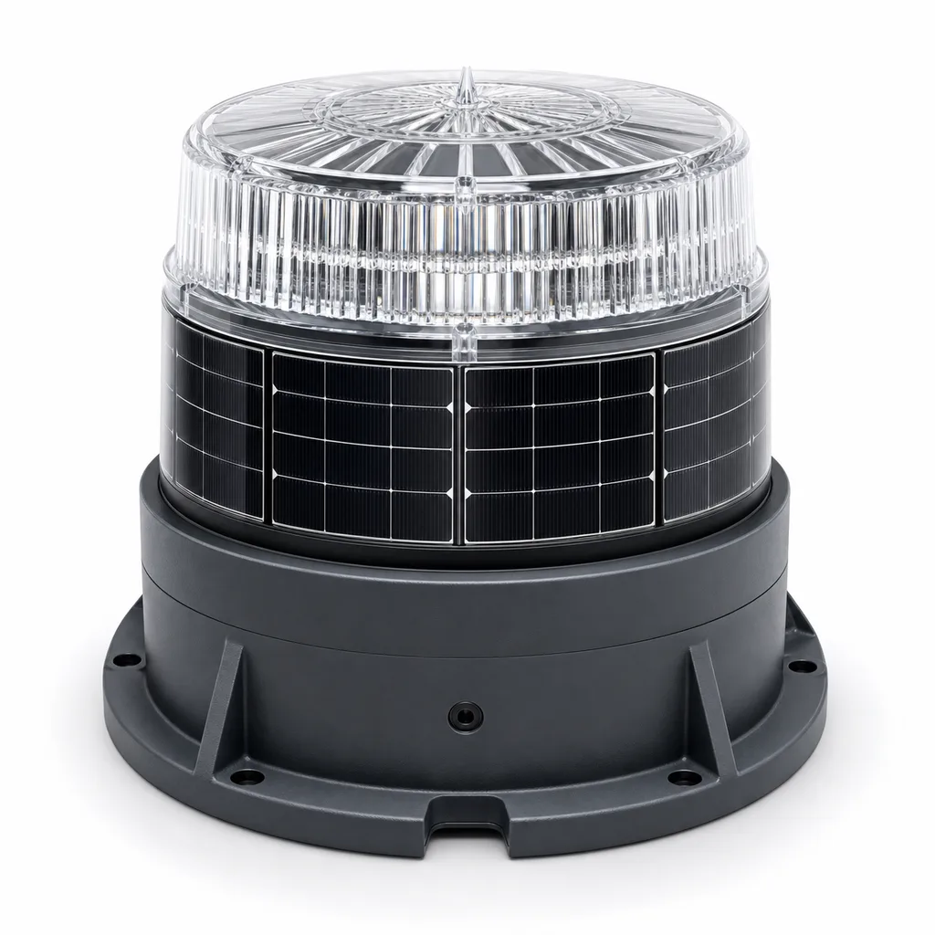
The Redcoast RC-MNL-300 is a self-contained, off-grid solar LED marine navigation lantern (aid-to-navigation / AtoN light) engineered for buoys, beacons, jetties, breakwaters, harbour entrances, bridge piers, offshore wind foundations, aquaculture farms and marine construction sites. It packs the solar panel, LiFePO4 battery, LED optic, charge controller, GPS synchronization module and an IoT telemetry gateway into a single sealed IP68 housing — no external wiring, no shore power. Redcoast designs the LED flash-driver board, MPPT power-management board and the GPS/IoT controller in-house, so flash character, intensity compensation and reporting behaviour are tuned to each authority's light list rather than bolted on from off-the-shelf modules. The result is a navigation mark that stays on-character through long polar nights, monsoon overcast and tropical heat, while telling operators exactly how it is performing.
Key Features
- IALA-aligned signalling: fully programmable flash characters (Fl, Fl(2+1), Q, VQ, Iso, Oc, LFl, Mo) with selectable colours — white, red, green, yellow and blue — to match published light-list entries.
- GPS flash synchronization: multiple lanterns marking a channel, gate or boundary flash in perfect unison for unambiguous night recognition, with timing held to sub-millisecond accuracy.
- In-house LED flash driver with intensity compensation: closed-loop circuitry holds programmed candela output stable across temperature, battery voltage and LED ageing, so the rated nominal range does not drift.
- High-efficiency MPPT power management: Redcoast's own charge board maximises harvest from the integrated monocrystalline panel and protects the LiFePO4 pack against over-charge, deep discharge and reverse polarity.
- Configurable nominal range 1 to 10+ NM: peak intensity from roughly 25 cd up to 475 cd depending on optic class, colour and flash duty.
- Remote IoT monitoring & control: cellular (4G/2G fallback), satellite or AIS-AtoN options report position, battery voltage, charge current, flash status, GPS-sync lock and tamper/tilt alarms; settings can be changed over the air.
- True autonomy: 15–30 days of operation without solar charging, sized per latitude and duty cycle.
- Tool-free commissioning: dusk-to-dawn photocell activation plus infrared/Bluetooth remote and PC/mobile app for flash-code setup and diagnostics.
- Marine-grade survivability: IP68 sealed enclosure, UV-stabilised lens, marine-grade hardware and salt-fog-resistant finish.
Technical Architecture
The lantern is a vertically integrated stack. At the top, a 360° prismatic optic of UV-stabilised polycarbonate (or acrylic) collimates the LED array into a horizontal beam with a tight vertical divergence to maximise on-horizon intensity. Below it sits the LED engine driven by Redcoast's self-developed flash-driver PCB: a microcontroller generates the precise on/off timing of the selected character, while a constant-current driver with temperature and voltage feedback holds luminous intensity on target. The integrated monocrystalline solar cells wrap the upper body and feed the MPPT power-management board, which charges an internal LiFePO4 cell pack and runs full battery-management (cell balancing, over-charge/over-discharge cut-off, temperature derating).
The control and telemetry layer is the differentiator. A GPS receiver provides a global time reference: every lantern programmed to the same character flashes on the same global clock edge, so an array reads as one coordinated signal even when units are kilometres apart. The same controller hosts the IoT gateway, which periodically transmits a health packet — GPS position, battery state of charge, daily solar yield, lamp current, character confirmation and any alarms — to Redcoast's web/mobile platform or to a customer's existing AtoN management system. Geofence and tilt sensing flag a buoy that has dragged its mooring or capsized. Local configuration is done over infrared or Bluetooth so the sealed housing never has to be opened in the field.
Connectivity & Power
Power is fully off-grid: integrated monocrystalline panel + MPPT + LiFePO4, with capacity and panel area selected for the deployment latitude, required intensity and worst-case overcast. For connectivity, cellular (4G with 2G fallback / NB-IoT) suits coastal and harbour marks within network coverage and gives the richest, lowest-cost telemetry; satellite (e.g. Iridium-class) suits open-ocean, offshore-energy and remote-island marks with no terrestrial coverage; AIS-AtoN broadcasts the mark to ECDIS and bridge displays for high-traffic shipping lanes; LoRa links clusters of nearby marks back to a single gateway on a pier or platform. Units can ship telemetry-only (monitoring) or telemetry-plus-control (remote re-tasking of character and intensity).
Protection & Reliability
The housing carries an IP68 rating for prolonged immersion exposure typical of buoy decks awash in heavy seas. Materials are chosen for the salt environment: UV-stabilised optical polymer, marine-grade stainless or powder-coated cast-aluminium base, and EPDM/silicone gaskets. The lantern withstands continuous salt-fog, driving rain, sand and UV, and operates from roughly -30 °C to +60 °C. LiFePO4 chemistry is selected for cycle life (typically 2000+ cycles) and thermal safety over lead-acid. Design service life targets 5+ years on the electronics and 8–10 years on the optic and housing, with the battery as the planned wear item. Reverse-polarity, surge and over-current protection guard the boards against field abuse.
Application Scenarios
- Channel & fairway marking: port-hand, starboard-hand and safe-water marks along approach channels, GPS-synchronised so a whole channel blinks as one readable sequence.
- Harbour & marina entrances: red/green entrance lights and jetty-head lights with reliable dusk-to-dawn operation and remote status to the harbour master.
- Offshore energy & cables: marking wind-turbine foundations, met masts, substations and cable-landing zones, with satellite telemetry where there is no mobile coverage.
- Hazard & wreck marking: rapid-deploy isolated-danger and cardinal marks on temporary buoys for new wrecks, dredging spoil or construction exclusion zones.
- Aquaculture & fish farms: marking the corners and perimeter of cage arrays and long-lines so night traffic avoids gear.
- Bridges & inland waterways: pier and span lights on river and canal crossings, often LoRa-linked back to a bridge control room.
Case-style Examples
Approach-channel modernization (port authority). A commercial port replaced ageing acetylene and incandescent buoy lights along a multi-kilometre approach with RC-MNL-300 units configured red/green per side, all GPS-synchronised. Mariners reported markedly clearer night identification of the channel edges, while the harbour office moved from scheduled boat patrols to exception-based maintenance driven by the telemetry dashboard — dispatching a vessel only when a unit reported low battery or a dragged-mooring alarm.
Offshore wind foundation marking. A developer marking turbine foundations far beyond cellular coverage selected the satellite-telemetry variant with high-capacity batteries and yellow Fl(5)20s characters per IALA guidance for offshore renewable structures. Synchronised flashing across the array gave a coherent night picture, and remote health reporting cut the number of crew-transfer-vessel trips needed purely for AtoN inspection.
Rapid wreck marking (response contractor). A salvage contractor kept a small stock of cardinal-configured lanterns for emergency deployment on temporary buoys. Because flash character and colour are field-programmable over IR/Bluetooth, a crew could re-task a unit to the correct cardinal quadrant on deck in minutes and have the wreck marked the same day, with position reported automatically once deployed.
Customization & Selection Guide
Start from required nominal range: short-range marina/inland marks (1–3 NM) use the compact low-intensity optic and a smaller battery/panel; channel and harbour marks (3–6 NM) use the mid optic; landfall, offshore and long-range marks (6–10+ NM) use the high-intensity optic with a larger pack. Then choose colour to match the mark's IALA role. Pick autonomy for the deployment latitude — high-latitude or heavily overcast sites need 25–30 days reserve and oversized panels. Choose connectivity by coverage: cellular near shore, satellite offshore, AIS-AtoN for busy lanes, LoRa for clustered marks. Add GPS synchronization wherever two or more marks should flash together. Finally select mounting to match the buoy or structure bolt pattern. Redcoast can adjust optic, battery sizing, mounting interface and reporting payload per project.
Deployment & After-sales
The lantern installs on standard buoy and beacon mounting patterns with marine-grade bolts; no field wiring is required because the unit is fully self-contained. Commissioning is done on deck via IR/Bluetooth and the mobile app — set character, colour, intensity and sync group, confirm GPS lock, and the unit begins autonomous dusk-to-dawn operation. Redcoast provides project-based lead times, configuration to the customer's light list, spares kits (battery packs, gaskets, optics) and remote diagnostic support through the IoT platform, plus optional integration into an existing AtoN management system via API.
Standards & Compliance
Designed to align with IALA Recommendation E-200 (marine signal lights, intensity, range and availability) and IALA guidance on AtoN, AIS-AtoN and offshore-structure marking. Component and product testing directions include IP68 ingress protection, salt-mist (IEC 60068-2-52), UV/weathering, vibration/shock, and CE / RoHS for the electronics. AIS-AtoN variants follow the relevant ITU-R M.1371 / IEC AIS messaging standards. Final flash characters and colours are always set to the responsible authority's published requirements.
Why Redcoast
Redcoast is a hardware-and-software house, not a re-brander. We design the LED flash-driver, MPPT power-management and GPS/IoT controller boards ourselves and write the platform that monitors them, so a project can ask for a non-standard character, a specific telemetry payload, a custom mounting interface or a bespoke intensity/autonomy balance — and get a board-level solution rather than a workaround. One supplier owns the lantern, the power system, the synchronization and the monitoring software end to end.
Talk to Redcoast about your channel, harbour or offshore marking project and we will configure and quote a solar marine lantern to your light list, coverage and climate. Contact us for a customized proposal.
Specifications
Optical & Signal
- Light Source
- High-intensity LED array
- Available Colours
- White / Red / Green / Yellow / Blue
- Peak Luminous Intensity
- 25-475 cd
- Nominal Range
- 1-10+ NM
- Flash Characters
- Fl, Fl(2+1), Q, VQ, Iso, Oc, LFl, Mo (programmable)
- Vertical Divergence
- 5-10 deg
- Horizontal Coverage
- 360 deg
Power System
- Solar Cell
- Integrated monocrystalline
- Charge Controller
- Self-developed MPPT
- Battery Chemistry
- LiFePO4
- Battery Capacity
- 15-120 (model dependent) Wh
- Autonomy (no charge)
- 15-30 days
- Battery Cycle Life
- 2000+ cycles
Control & Monitoring
- GPS Synchronization
- Yes (sub-ms timing)
- Telemetry Options
- 4G/NB-IoT / Satellite / AIS-AtoN / LoRa
- Local Configuration
- Infrared / Bluetooth + mobile app
- Activation
- Dusk-to-dawn photocell
- Reported Data
- Position, SoC, charge current, flash status, sync lock, tilt/tamper
- Intensity Compensation
- Closed-loop (temp/voltage/ageing)
Mechanical
- Optic Material
- UV-stabilised polycarbonate / acrylic
- Base Material
- Powder-coated cast aluminium / 316 stainless
- Lantern Height
- 200-450 (by class) mm
- Lantern Diameter
- 155-300 (by class) mm
- Mounting
- Standard buoy/beacon bolt circle (custom on request)
- Weight
- 2-12 (by class) kg
Environmental & Protection
- Ingress Protection
- IP68
- Operating Temperature
- -30 to +60 deg C
- Salt-Mist Resistance
- IEC 60068-2-52 direction
- UV / Weathering
- UV-stabilised, long-term outdoor
- Design Life (electronics)
- 5+ years
Compliance
- Signal Standard
- IALA Recommendation E-200 (aligned)
- AIS-AtoN
- ITU-R M.1371 (variant)
- Electronics
- CE / RoHS
- Ingress Test
- IEC 60529 (IP68)
Capabilities — configurable per project
Specifications are tailored to each project — the options below show what we can support.
Range Class
- 1-3 NM (short)
- 3-6 NM (channel/harbour)
- 6-10+ NM (offshore/landfall)
Signal Colour
- White
- Red
- Green
- Yellow
- Blue
Connectivity
- 4G/NB-IoT
- Satellite
- AIS-AtoN
- LoRa
Synchronization
- GPS-synchronized
- Standalone
Mounting
- Buoy deck
- Beacon/pile top
- Jetty/breakwater bracket
- Custom bolt pattern
Related solution guidance

Environmental Monitoring
Deploy environmental monitoring stations with sensors, solar power, gateways, dashboards, alarms and data integration for city and industrial sites.
Power and Connectivity
How to choose power, battery, solar, NB-IoT, LTE, LoRaWAN, gateways and monitoring strategy for outdoor IoT infrastructure.
Ports and Logistics
Outdoor IoT infrastructure for ports, yards and logistics areas: lighting, guidance, safety, solar power, monitoring and maintenance visibility.
Frequently Asked Questions
What is a self-contained solar marine lantern?
It is an aid-to-navigation light that integrates the LED optic, solar panel, LiFePO4 battery, charge controller and electronics in one sealed IP68 housing. It needs no external power or wiring and runs autonomously dusk-to-dawn, which makes it ideal for buoys, beacons and remote marine structures.
Is the RC-MNL-300 IALA compliant?
It is designed to align with IALA Recommendation E-200 for marine signal lights, including programmable flash characters, colours and intensity/range. Final character and colour are configured to the responsible maritime authority's published light list, and AIS-AtoN variants follow ITU-R M.1371.
How does GPS flash synchronization help?
GPS provides a common global time reference so multiple lanterns set to the same character flash in perfect unison. This lets mariners read a channel, gate or hazard boundary as one coordinated signal at night, even when the marks are far apart, reducing the risk of misidentifying individual lights.
What nominal range can the lantern achieve?
Configurable from about 1 NM for marina and inland marks up to 10+ NM for landfall and offshore marks. Range depends on the selected optic class, signal colour and flash duty cycle, with peak intensity from roughly 25 cd to 475 cd.
How is the lantern monitored remotely?
An on-board IoT gateway reports GPS position, battery state of charge, charge current, flash status, GPS-sync lock and tilt/tamper alarms to the REDCOAST.LTD web/mobile platform or a customer AtoN system. Telemetry can run over 4G/NB-IoT, satellite, AIS-AtoN or LoRa depending on coverage, and settings can be changed over the air.
How long does it run without sun?
Autonomy is typically 15 to 30 days with no solar charging, sized to the deployment latitude, required intensity and worst-case overcast. High-latitude or heavily clouded sites use larger panels and battery capacity for the longer reserve.
Can REDCOAST.LTD customize the flash character, telemetry and mounting?
Yes. REDCOAST.LTD designs the flash-driver, MPPT and GPS/IoT boards in-house, so flash character, colour, intensity, autonomy, telemetry payload and mounting interface can be tailored to a project rather than limited to fixed presets.
Is it suitable for offshore and high-salt environments?
Yes. The housing is rated IP68 for immersion exposure, built from UV-stabilised optical polymer and marine-grade aluminium or 316 stainless with salt-mist-resistant finishing, and operates from -30 to +60 °C. Satellite telemetry variants suit offshore sites beyond cellular coverage.